- 2 Nights
Essential Gear
- Capable 4WD with low range
- Recover equipment
- Good off-road tyres
- Plenty of food, water and warm clothes!
- GPS, Maps and compass
Itinerary
Day 1
- Getting to Licola – Entry point into the Victorian High Country
- 1st night – Camp along the Wellington River just north of Licola
Day 2
- Bennison Lookout
- Pinnacles Lookout & Firetower
- Billy Goat Bluff Track
- Crooked River Track
- Talbotville – Camp overnight – Historical township from the gold rush era
Day 3
- Grant – Historical township from the gold rush era
- Dargo
Difficulty / Driver Experience
It’s recommended that this trip is embarked on by intermediate to advanced drivers and navigators in two or more capable 4WDs with low range and appropriate recovery gear.

Overview
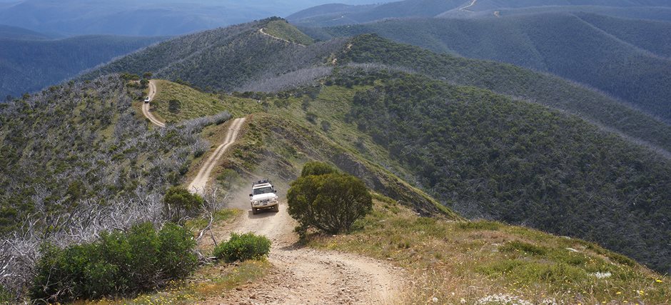
The Victorian High Country is a premier camping and 4WD destination that combines breath taking scenery with some of the most spectacular 4WD tracks. Located just 3 hours drive from Melbourne, it’s also extremely accessible, even for a quick weekend adventure. Like a highlight reel, this 3 night 4WD and camping trip through the high Country will lead you to a number of iconic, must visit places. Such a trip is perfect for a long weekend and provides a real taste of what the High Country has to offer.
Where abouts is the High Country?
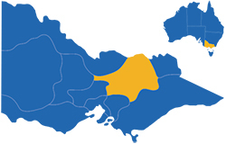
The Victorian High Country covers a large part of South-Eastern Victoria, with much of the area only accessible via a 4WD. With a huge range of tracks and campsites on offer, the majority of which are completely free of charge, the high country is truly one of the premier camping and 4WDing destinations in Australia.

Best time of year to Visit the High Country?

Being an Alpine region, winters in the Victorian High Country are undoubtly cold. The For this reason, most of the 4WD tracks in the region are closed for from the start of June to November. Parks Victoria website keeps a detailed list of road and track closures. As tracks re-open, they are often slippery and treacherous in some places, especially after any amounts of rain, care and patience must be taken. This is not a problem during hotter months, as the tracks dry out and become quiet dusty.
Day 1 – Licola, Victorian High Country
The adventure starts at Licola, which is located on the South Eastern edge of the High Country, about a 3 hour drive from Melbourne. This is your last chance to refuel and pickup any last minute supplies from the General Store. Both Diesel and Unleaded types are available. There are plenty shady parks with rest areas nearby for lunch or a quick stop over.
From Licola, head North on the Tamboritha Road for 13kms and you will reach Currawong Camp, which is the first of several scenic campgrounds in the Wellington River Camping area. This is a fantastic option for your first overnight camp.
Wellington River Campgrouds – Victorian High Country

The Wellington River Camping area offers a dozen campgrounds, spread out along a 10km stretch of the river bank.
Outside of peak periods such as summer long weekends or Easter, there should be plenty of availability to setup camp. Finding each campground is straight forward since all campgrounds are clearly sign posted and easily visible from Tamboritha Road.
Day 2

Image: @andykdoughty
After a night around the campfire, head out east along Tamboritha Road until you reach Bennison Lookout, which is worth a stop as it offers fantastic views towards Lake Tali Karng, Mount Wellington and the Razorback.
Continuing along the high plains on Tamboritha Road and you will arrive at Arbuckle Junction. At this point, turn slightly right onto Moroka Road and continue to head east. 12km from Arbuckle Junction is MacFarland Saddle, which is the trail head for the Lake Tali Karang walking track.
Lake Tali Karng is a hidden jewel nestled deep in the mountains of Gippsland, fed by snowmelt waters of the Wellington Plains. The lake is one of Victoria’s deepest natural lakes and is believed to have been formed about 1500 years ago when a massive rock slide collapsed into the valley damming the waters of Nigothoruk Creek above Wellington River. The walking track is a 31km round trip on foot and takes most hikers 2 days.

Pinnacles Lookout and Fire tower
From MacFarland Saddle Carpark, continue along Moroka Road for another 14kms and you will cross the Bridget that spans Moroka River. Keep going for another 15 kms and you will reach the Pinnacles Lookout and Fire tower. At this point, park your 4WD and head out on foot. Its a short but steep walk up to the fire tower lookout perched on a rocky summit. When you arrive, you will be rewarded by breathtaking panoramic views of the High Country. On a clear day, you can see as far as Gippsland Lakes, Mt Hotham to the north and the settled areas of the Wonnangatta Valley far below.

Image: @visitmelbourne.com
After a selfie fill session at the Pinnacles lookout, head back down the same road until you reach the turn off for Billy Goat Bluff track. Now its time to prepare for some adrenaline filled 4WDing ahead!
Billy Goat Bluff Track

Track Facts
- Length: 9.5km
- Access: Closed during winter and on catastrophic fire danger days. Check with Parks Victoria to ensure the track is open before you leave home.
- 4WD only with high clearance and low range capability.
Billy Goat Bluff is considered one of the most challenging and scenic tracks in the Victorian High Country. Recommended for those with the proper 4WD training, experience and well prepared vehicle, you can take on this challenge with confidence.
It starts with an incredibly steep ascent, elevating 1,200 metres in just 7kms before descending 950m to the valley floor below. From end-to-end, Billy Goat Bluff track is less than 10kms but due to the challenging terrain, its advisable to schedule at least an hour for this trek. The rocky track surface is very slippery when wet so avoid any attempts in poor weather.
The track itself is extremely narrow at places, with cliff faces on both sides. Passing on coming traffic at these bottlenecks can be extremely challenging. Be considerate of others on the track. Move aside and let on coming convoys pass in safety. Keep your radio handy so you can stay in constant communication with your convoy and other vehicles on the track.

Image: @80series_domination
At the bottom of Billy Goat Bluff is where the track meets Wonnangatta Road. Turning left will take you through to Eaglevale and onto the iconic Wonnanngatta Station, but on this outing we’re turning right towards Dargo.
Follow the Wonnagatta Road for 6kms and you will reach the Kingswell Bridge which crosses the Wonnanngatta River. Make a left turn immediately after the Bridge onto Talbotville Road heading east. Continue to follow the road along the river for another 6km then take a left onto Crooked River Track.
Crooked River Track

Almost immediately after starting down Crooked River Track, you will come to the first of 20+ river crossings along this track. While most of the crossings are small, there are a few deeper ones to watch out for. Most of the time, these crossings are straight forward, however if its been raining recently, take caution and plot your course along firm footings.
Continue following the Crooked River Track north, through farmland, then some forested areas for 9km, until you reach a large grassy opening. You have arrived at the historical Talbotville Camping Area.
Talbotville – 2nd Overnight Camp

Talbotville was another of Gippsland’s small gold mining towns that sprang to life when gold was found in the Crooked River in 1860 but vanished when the gold ran out. About all that remains visible of the township are a few stonewalls and the old gold mines in the area.
Today Talbotville is a beautiful camping area bordered by the Crooked River with lush green grass even when the surrounding bush land is so dry and dusty. The Talbotville camping area has plenty of picnic tables and fireplaces with cooking plates and fresh water flowing in the Crooked River.
Up stream from Talbotville along the Crooked River there are plenty of old gold mining sites including the New Good Hope Mine and further along to the area of Stonewall with its old gold mine and the remains of the fireplace and oven which are more often than not covered by black berries.
Day 3 – Township of Grant
From Talbotville head east towards Grant, which is approximately 11km via McMillian Road. During the gold rush era, the township boasted a population of 2,000. To support the community, stores, churches, banks, hotels and even a police station was present. Unfortunately, little of this remains today. There are some information boards position along walking tracks which provide commentary into the story of this former mining town.
From Grant continue along McMillians Rd for another 5km then turn right onto Dargo High Plans Rd and continue for another 18km until you reach the town of Dargo.
Gateway into the Victorian High Country – Dargo
 For those who want to call it a weekend, head south from Drago along Dargo High Plains Rd. From Dargo Melbourne is around a 4 hour drive.
During the gold rush era, the town of Dargo provide a stop over for miners on their way to the goldfields of Grant, Talbotville and Crooked River. Today, Dargo is a very popular destination for 4WDers and is considered a hub of the Victorian High Country. For those heading into the High Country, Dargo offers a chance to grab some last min supplies and fuel from the General Store.
In my opinion, a high priority is to visit the legendary Dargo Pub. This iconic pub delivers an authentic country pub atmosphere and is a fantastic place to enjoy a drink and a meal. If you wish to make a nigh of it, camping is available out the back of the pub or over at the Dargo River Inn.
From Dargo, Melbourne is about a 4 hour drive.


